Sunday, August 26, 2012

White Rim Preliminaries


I have had cycling the White Rim on the list of must do adventures for a number of years. The trail is in Canyonlands National Park south of Moab, Utah. It traverses a loop down the Colorado River valley and up the Green River Valley under Island in the Sky. The trail is a former mineral exploration road named for the sandstone cap rock that the route is mostly on. The version we did is about 75 miles long, starting from Shafer Overlook  near Canyonlands Visitor Center and ending where our truck picked us on top of plateau along Mineral Bottom Road. Logistics are difficult as there is no water available along the way and the climate can be extreme desert heat, as well as rain as we learned….

This year 6 of us, (let’s call us Dave, Heidi, Robert, Barb, Elaine and Brian) decided we could make this happen. Robert generously offered not to ride a bike and to bring his F150 complete with ‘Northern Lite’ camper as support vehicle. Much searching of internet blogs provided evidence that a camper such as Roberts could make this voyage. Although closer to the event Robert decided he would do an out and back to Potato Bottom, in order to avoid some tricky ledges after Hardscrabble…..

To camp on the trail, a group requires a Canyonlands Backcountry Permit. Apparently not a difficulty to obtain one in August as most folks think weather is too hot in summer and do this trip in shoulder months. Anyway for a couple reasons, we booked August 20 to 23. Our group  gathered in Moab on 19th August 2012, completed the formal permit/indoctrination process with Gretchen at the Canyonlands visitors center and were ready to go. Map on right is decent cartoon of the area.

Day 0 - The Intrepid Loop – Dead Horse Point State Park


As a warm up, and for some an introduction to mountain biking, four of us rode the Intrepid Trail in nearby Dead Horse Point State Park after the short White Rim information session at Canyonlands.

This delightful up to 9 mile loop, brought to us by our favourite Potash company (their operations can be observed from viewpoints on the trail) has enough challenges and provides first hand experience in navigating rocks, sand and ledges.

For a mere $10 entry fee per vehicle one soon finds themselves rolling along a nicely laid out and well maintained trail system that allows mere mortals a chance to say they mountain biked in Moab. 

We chose a clockwise version of the Big Chief loop that left us confident and excited for the main event. Temperatures were in the mid 30's C (95 F) and it was still well before noon when we were done. Much water was required, and of course a few beers later to top up....


Day 1 Shafer Overlook to Airport Camp.


Shafer near the top
The alarm rang in our Moab motel room before 5:00 AM. In the heat of the summer season an early start is mandatory. With a quick breakfast and some predictably nasty motel room coffee, we are on our way to the trailhead. With minimal messing around we are on the bikes and start descending the Shafer road by 6:45, the sun is just rising. 

Shafer Road emerges from canyon
Having looked down on this road in prior visits to Canyonlands, I have an appreciation for the civil engineering marvel the road is. It drops over 1000 feet in 4 miles in a series of carefully crafted switchbacks. 


The road is (at least was on August 20, 2012) a well maintained dirt road of reasonable width for a full size pickup and with ample pullout areas to pass oncoming traffic should that be required. We saw no other vehicles in the hour it took us to descend. Great views, exciting riding make this a must ride.
One of many switchbacks
Brake lights were on a lot


Shafer joins the White Rim Trail at mile 4, the Potash road junction. Toilet facilities are located at this point for any required housekeeping that may be necessary after the descent....


Beer Oclock
 After Potash road junction the road mellows out to undulating along the Rim. Even time for refreshments....

For cyclists a pleasant spin, for a vehicle with a camper some issues with a few tilted spots. It was helpful for the driver to have a spotter on some of the trickier places.


A few miles along the Colorado River overlook is a spectacular viewpoint.
worthy of setting down the bike and wandering out to.
Colorado Overlook

Musselman Arch


Barb on Musselman Arch


About half way to Airport Camp you reach Mussleman Arch. This feature is well worth the short side-trip of a few hundred metres.

It's a cool arch about 60 metres long, 2m wide and with 100m of air beneath it... some folks apparently ride their bikes across it....? One of us had sufficient courage to walk across.


From the Arch it's about 8 miles to Airport Camp, mostly flat with one not insignificant climb/descent.


By 11:00 we are at Airport Camp, the temperature is 38C. The clouds that have been our savior for the last 4 hours have deserted us. Our driver is last to arrive, has found the bikes difficult to keep up with in the unpaved terrain. Who knew his job would be so demanding? Nevertheless he soon has a delicious snack of side ribs heated to restore the energy levels of the cyclists. Cold beer is extracted from the refrigerator to assist in hydration process.....

A sun tarp is setup but with lack of much other than the truck to stake to it is not a big success with the sporadic wind gusts. We note from the instructions that they do not recommend using in windy conditions? It is stuff stowed (which is apparently not the correct way to put something in a 'stuff sack' ) and it is not seen again.

The camp has a decent toilet facility that was maintained by Park staff while we were there, clean enough  to eat off the floor of if one was inclined... but prop the door with a rock, the heat is unbearable. There is little interest in side trips farther than the toilet, we relax and rest for day 2.

Day 2 - Airport Camp to Murphy's Hogback


After a warm night sleeping in the tents with no fly, making for great star gazing and even the occasional shooting star, we arose early once again to try to take advantage of the cooler (ok, less hot) early morning temperatures. Today will be our longest day - 26 miles (42 km) with a nasty climb at the very end. We have a quick breakfast of some cereal or yogurt and nasty instant coffee and then on to the bikes. 

There is only enough cloud in the morning to make the sunrise pretty, a stinking hot day awaits. The views today are quite dramatic with many deep canyon views – not for the faint of heart. 

The camper today has early challenges with a feature called the ‘big tilt’ an off-camber traverse. Our driver, self described as fully experienced from 'years of reading off road 4x4 magazines' is feeling confident in driving and does very well. The photo opportunities are many today. Unfortunately we encounter sand which makes the riding more difficult. Lots of effort for not as much gain. The government maintenance pickup passes us going the other way today. 
 
We stop for a snack break at the turn-off to the “white crack” we do not have the time to travel the extra few miles to see it and still get finished before the day gets too hot, another time maybe. 
The Big Overhang
 Instead we enjoy oranges from the refrigerator in the camper. Delicious. 
Monument Basin

We are passed by a lone person on a motorcycle, and later another two motor cycles and a pickup pass our camp. No others camping at the adjacent camps tonight either, only a few day trippers and the government truck to clean the facilities and top up the paper are our White Rim companions.
The temperature continues to rise, beer o'clock not in the cards today. ...we persevere through more heinous sand. One of riders takes an unhappy fall when the front wheel gets bogged down in the sand and the rest of the bike keeps moving. A nasty gash to the right leg accompanied by a side order of road rash requires sand removal and first aid attention later at camp to avoid complications. 


Camper approaches Hogback Climb
We know we have the infamous Murphy’s Hogback to climb. It is featured in many of the You-Tube videos that some of us had watched. We start a climb – we’re tired and hot. We meet a couple of European hikers down from the highway, apparently wandering aimlessly in the desert  – what are they doing out here? they suggest we may be crazy?? Could this be the famous Hogback? 
Murphy Hogback final climb


We cannot see where the trail leads and then round a corner and we see the final climb. It’s the steepest and longest of anything we’ve seen. There is a 2 part harmony chorus of “Holy S..t” So we start the push, none of us even considers attempting to ride it.  A grand sufferfest is had by all as we struggle up the final grade. Eventually we all make it to the top where the hot desert sun is burning down on us. Most of us are suffering one or more symptoms of heat exhaustion....  Our more than 325 years of combined life experience weighs heavy....

The camper arrives and the thermometer on the truck reads 41C. Yikes, that’s way too hot. We take turns sitting in the air- conditioned cab of the truck. I drink my chocolate bar. 
Then we find shade behind a large rock and stay there the rest of the day. We enjoy a cool Costco watermelon, tasted good enough to be stolen. Wonderful.  Our spray bottles are also very welcome as we hide behind the rock for shade.... 

A delicious meal of back ribs and fixings is prepared by the driver and partner, they get no rest, we drink more beer, play a rousing game of Boce trying not to hit the cook and risk food related punishment.

Delicious Ribs
Luckily the wind picks up late to cool us down. And wait now, clouds are forming in the west, fair weather cumulus no doubt, it doesn't rain in the desert.... 

Some discussion now ensues about strategy of reversing road in Camper after day 3. Becoming clear it would take a lot of time to drive back and spotter would be required. Possibility of taking Camper all the way around now actively being considered. A few members of the party scout the downward side of the Hogback in anticipation for the morning. The report is 20m of  ' will be pushing bike down'. The driver finds little comfort in the report and sleep is affected by more than weather and ladies wearing nothing but glasses going outside and adjusting camping tables and related equipment.
Green River basin from Murphy Camp

We set up the tents without their flies to enjoy the desert stars. Mother nature treats us to an excellent lightning display after the sun sets. We figure odds better than 50/50 it won't rain on us.  Then before we are even able to get settled in the tent, winds pick up even more and the rain starts, best if we don't go all in when we gamble I guess. Screams are heard, a panic ensues getting the tent flies back on. The tents and the camper shake and rock much of the night, and not in a good way....  

Day 3 Murphy to Potato Bottom


Murphy Morning
Up early again, although we expect a shorter, easier day. Today is variously estimated but expected to be approximately 20 miles. The rain has largely been soaked up by the sand and dry air, isn’t enough to affect the ride. There is cloud cover again so expecting a cooler day than yesterday.

Descending Murphy Hogback North
The truck edges over to the down ramp on north side of  the Hogback, indeed the first 20m or so is steep, but nevertheless rideable and driveable, a few overhangs but no major difficulty, we are soon racing down toward the Green River. 
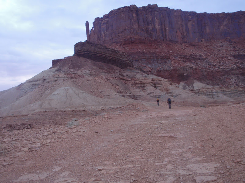


The Candlestick
Sand is again an issue, harder work and have to pay more attention, almost rear ended Elaine, never appreciated, had to take one into the dirt to avoid, my punishment for following too close.Travel is generally downhill/flat circling around the interesting feature known as Candlestick. A short break at Candlestick Camp and onward to Holeman slot canyon.


Holeman Slot Canyon
The cyclists stop to explore Holeman slot canyon, a cool feature worth a visit. The Camper heads onward figuring to wait for spotter if difficulties arise. We descend a small distance down the slot canyon, a bit tricky with bike cleats. A fair bit of mud is encountered and we decide we have seen enough.  

Green River
Back on the bikes we head to Potato Bottom, the camper is nowhere to be seen, travel apparently good. The sand eventually lets up and we enjoy a pleasant ride down to Potato Camp on banks of Green River.

Potato Bottom Cottonwoods


Potato Camp is much less desert like, cottonwood trees shade the camp, swallows and bats swoop over the camp. Very interesting that the bats were out in middle of the day enjoying some delicious insect hatch. We enjoy more watermelon and re-hydrate with a few beers.

The Ark?
Potato Bottom in the Rain
Our hanging around in the sun is disturbed by a very heavy rainstorm. Within a few minutes most of the camp has water running over it. Most run for cover in the camper, but the rain is warm and not uncomfortable, I take the opportunity to take a few photos.
It only lasts 30 minutes at most.

Purple Rain
The rain provides insight as to where to pitch tents, selection of spots is reduced from what seemed like a dozen when we arrived, to only 2 that were above the water line after the rain.

Dave makes the surprising observation that today and for that matter all of the last three days were all longer than any previous cycling trips that they had done. As they were leading the charge most of the time apparently they are quick studies. 

 A jeep passes by on a day trip to Candlestick, the young driver provides insight that our Camper cannot possibly navigate over the Hardscrabble hill. We decide that our driver has had enough sleepless nights and avoid sharing the young man's opinion with him. How hard can it be?

Potato Camp C Facility
The Potato Camp C toilet facility is located some distance from camp, taking the bike significantly reduces travel time, at night it is a long lonely journey.
A delicious pasta with vegetable and meat sauce is served up and fully enjoyed. It’s day three out, and the 9 dozen beers we started with have dwindled to a mere 8 cans as night approaches. Seems we planned well not withstanding an initial discussion as to volume of hydration beverages to take. 

As night falls, again there is debate about fly or no fly, it is removed after midnight and reinstalled a short while later as a light rain starts.

Day 4 - Potato Bottom to Mineral Bottom Road

Hardscrabble Shoulder

Climbing up Hardscrabble from south
It rained on and off most of the night, temperatures in morning considerably cooler than previous days. The sky is filled with ominous looking clouds that obscure the sunrise. 

Descending Hardscrabble
Today is the shortest day, 12.5 miles to junction with Mineral Bottom Road, from there the truck will take leave of us and take Dave to get the vehicle left at Shafer overlook. The rest of us will struggle up Mineral Bottom and meet the truck somewhere on the road.
Rock Fall Hardscrabble Ledges
 
We break camp and head for the climb up Hardscrabble Hill. Hardscrabble Hill climbs about 500 feet out of the river bottom and traverses a ledge system to get you over the Bighorn Mesa and back to the Green River. It is narrow in places, has some rock fall on road and has some overhanging ledges that cause concern for hardsided camper operators. We went slowly, spotting the vehicle around the rock fall and overhanging ledges, clearance was pretty good in all places. The camper had to get a bit closer to the downside road edge than driver may have preferred in a couple places, but made it through with nothing worse than touching a jack stand to a fallen rock that crowds the road a bit. Cycling is very good, quite rideable both up and down and a very fun descent to the Hardscrabble Bottom. 

Hardscrabble Bottom
The trail runs along Hardscrabble Bottom where a few more ledges are encountered. Again none caused serious concern, but spotting required. As we approached Labyrinth Camp, we encountered wet sand in the wash that made the cycling a bit more interesting. But in general it is a very pleasant ride along the river.
Saddle Horse Bottom
Once to Labyrinth we figured we had it beat and sent the camper on his way ahead of us. But wait, not so fast… we soon catch up to the camper, there are some more ledges to navigate past at beginning of Saddle Horse Bottom. This turns out to be the most difficult spot on the route as the overhang is low and road is narrow. With one stop to reverse and get a better angle to avoid the overhang, we creep by the obstacle. The truck wheels on the downside were somewhat uncomfortably close to the edge of the road, no matter we are past it and the driver has already stated he won’t be repeating this adventure, at least not in this vehicle.
Mineral Bottom Junction
Camper exiting on Mineral Bottom Road
The rest of the ride to Mineral Bottom Road turnoff is pleasant along the river. Once outside Canyonlands Park, the road seemed to improve, wider, less rough… different budgets no doubt. We are soon at the Boat launch junction and the drivers and truck leave us to climb out Mineral Bottom Road. This road climbs some 1000 feet in 1.5 miles to Horsethief Point. The road was closed in winter 2010/2011 due to a major washout, it has been rebuilt and is now a reasonably wide, smooth surface dirt road. Wash areas have even had concrete poured to minimize erosion.
Heading up Mineral Bottom Road

Mineral Bottom Auto Graveyard
The road is quite rideable, but we chose to mostly push the bikes up as the 4 days of riding had taken a toll. Of interest at one switchback there is a graveyard or rusted auto bodies… Portions of at least 4 car bodies can be seen protruding from the rocks below. Not sure whether these were fill for the road work or remnants of past mis-adventures.

Looking down to Mineral Bottom
Shortly we crest the top and ride on toward Utah 313. A light rain starts, that gets heavier as we proceed, an hour and ¼ after they departed the truck returns to pick us up, the rain is heavy now, we are glad to get in out of the wet. We are 4 hours of riding from Potato Camp.
Cycling on Mineral Bottom Road


Done
The White Rim is behind us. Four days traveling approximately 75 miles in about 18 hours of riding. Some very interesting terrain traveling through one of the most stunningly beautiful landscapes on the planet. Highly recommended....